The Roman invasion of
Britain, 43 AD: riverine, wading and tidal studies as a means of limiting the possible
locations of the invasion-ground and the two-day river battle
Steve Kaye, March 2014
Contents
.
Abstract
.
Historical and archaeological knowledge
of the invasion
.
The contesting theories related to the
landing-site
.
The two-day river battle - in which month?
.
River wading: modern studies, Roman methods and
capabilities
.
The reconstruction of the non-tidal hydrology of
SE England
.
Combining hydrology with wading limits
.
Tidally influenced rivers in 43 AD
.
The Roman line of approach to the Medway
.
Discussion of possible landing-grounds in 43 AD
. Summary
Abstract
Archaeological evidence is lacking for the Roman invasion of Britain in 43 AD. Cassius Dio wrote of the episode but omitted locational information during the combat stage except for references to the river Thames and Colchester. Consequently much effort has been expended in the use of circumstantial archaeological evidence and applied logic to propose numerous locations for the invasion-ground and the battles. This has resulted in two schools-of-thought: for invasion-grounds on either the coasts of Kent or Sussex.
However, prior to the Romans reaching the Thames, Dio relates that a unit of the auxiliaries, the Keltoi, unexpectedly, as far as the British were concerned, swam another river while in full-armour. This event, the opening phase in a two-day battle adjacent to a river, eventually led to the withdrawal of the British force across the Thames.
The goal described in this essay was to use this swimming episode to provide locational information for the two-day river battle and hence the most likely location for the invasion-ground.
To that end, all the rivers existing in 43 AD in the southeast of England were reconstructed, the wadeability of rivers assessed, relative sea-level changes since 43 AD examined and tidal regimes determined.
The conclusion is that only the river Medway required the Keltoi to swim across and that, consequently, the most likely location for the invasion-ground is on the coast of Kent.
Acknowledgements:
nearly all the computations and maps in this essay were created in the Free
Open Source Software, SAGA. Nici
Lilley, yet again, has kindly applied her editing skills but any remaining
errors are the author's.
Historical and archaeological knowledge of the invasion
Cassius Dio is the only ancient writer to leave us a moderately detailed account of the invasion, but he was writing in the early 3rd century, using earlier detailed accounts, some of which are now lost and he had a tendency to be less than specific, particularly regarding location information. (Dio, Roman History: Book 60. Ernest Cary's 1914 translation can be read here.)
In brief, Dio reports that in 43 AD the Roman army, commanded by Aulus Plautius, sailed westwards from the European mainland in three divisions or groups, and landed unopposed somewhere in southern Britain. Plautius then marched inland, first defeating Caratacus and then Togodumnus, before confronting a combined British army across a major river. Units of Plautius' auxiliary force, trained to swim in full-armour, crossed the river and engaged the British. Subsequently the main Roman legionary force crossed the river and, over a two-day battle, caused the British to retreat across the Thames. After a brief pursuit Plautius halted his operations near the Thames before sending for the Emperor Claudius to participate in the final battle and the consequent capture of Colchester, the seat of tribal resistance. Claudius, after only 16 days in Britain, returned triumphant to Rome, leaving Plautius to continue the conquest of Britain.
Dio does not mention from where the invasion force sailed, where it landed, where Caratacus and Togodumnus were defeated, or where the two-day battle at the river occurred. Luckily Dio mentions the river Thames on a number of occasions after the two-day river battle, for example:
the Britons retired to the river Thames at a point near where it empties into the ocean and at flood-tide forms a lake.
Placing the post-battle combatants at the Thames, coupled with a logical geographical progression for the Roman advance, means that the sites of the landing ground, earlier battles and the two-day river battle were located south of the Thames and lay within southeast (SE) England (the modern counties of Kent, Surrey, East and West Sussex and Hampshire).
As for the composition of the Roman army, only the 2nd Legion (Augusta) is mentioned in the ancient sources (Tacitus, Histories). However, after many decades of research and consideration, most workers would agree that the army consisted of four legions, the 2nd (Augusta), 9th (Hispana), 14th (Gemina) and the 20th (Valeria Victrix), plus an equal number of auxiliary units, i.e. approximately 40,000 fighting men. To emphasise, there is no evidence for the presence of any legion except the 2nd; for the auxiliaries all that can be said is that some 'Keltoi', i.e. Celts (Hoffmann, 2013) were present who swam across a river(s). Nevertheless, the lack of historical evidence can be glossed over by the sheen of academic research, and the 40,000 fighting-man figure was accepted in this essay.
Dio probably names the Keltoi because of their exceptional ability, in that they were trained to swim in full armour which allowed them to immediately engage the enemy. It was exceptional in relation to the rest of Plautius' army for, although legionary recruits were taught and practised swimming (Vegetius, De Re Militari: Book 1,), it was not conducted in full armour and its lack would leave them exposed and vulnerable once they had swum any river. Indeed, such legionary feats might have been impossible, or at the least, very dangerous and costly in drowned lives, for the armour of the legionary was probably much heavier and more restrictive than the auxiliary Keltoi. To be clear with regard to Dio's account, legionaries may have swum across towing their armour and arms resting on shields encased in water-proofed leather bags or small reed rafts, but they would not have been immediately prepared to attack or defend. Sadly, Dio does not relate how the legionaries crossed.
Turning to the archaeological record for evidence of the invasion ground, battle sites, river-crossing points, temporary marching camps, or any other confirmed physical relict of the invasion leaves only one conclusion: there is none. But, as Birgitta Hoffmann reminds us when discussing Roman Britain, absence of evidence is not evidence of absence (Hoffmann 2013).
The contesting theories related to the landing-site
The absence of evidence, the long coastline and a broad hinterland for operations has allowed numerous workers to put forward many interesting accounts of how the Romans might have conducted the invasion. Much heat, but little proselytising light, has been generated by subsequent discussions, not least amongst those who propose a landing-ground in either Kent or Sussex. Indeed, it can be said that supporting either county defines and divides, in the broadest of terms, those who currently study the invasion.
Of the Kent locations, Richborough dominates the discussion with access via the Wantsum Channel, but with minor mentions for Lympne and the coastal stretch from Deal to Sandwich. In Sussex the landing-ground is thought to be east of the Solent from Porchester to Chichester (Fishbourne), with the latter being most favoured (Figure 1).
For all accounts, for any
landing-site, in either county, the movements of the Roman army must have
brought it to the Thames where it meets the sea, was tidal and had low-lying
land, probably at the ebb-tide, and where it could be crossed by foot.
Necessarily this means that the two-day river battle must be located south of
the Thames and at one of the main rivers shown in Figure 1. This simple fact,
if one accepts Dio's account, allows for a hydrological examination of the
two-day battle that places severe limits on which rivers could have been
involved. But, before the limits can be defined, the battle must be discussed.

Figure 1: Topographic map of SE England showing the main candidates for the landing-ground in 43 AD: in Kent at Richborough, Lympne and the coast between Deal and Richborough; in Sussex between Porchester and Chichester (Fishbourne). Current coastline shown. The rivers are naturalised and may not match current locations. Roman roads (purple) are for reference only - they did not exist in 43 AD.
The two-day river battle
Prior to this major battle the Romans had defeated the British in two, probably, smaller battles or skirmishes, had advanced further from the landing-ground and, presumably, moved closer to the Thames. The presumptions at this point, in this essay, are not important. Dio's account now says that the Romans advanced and came to a river. Dio continues:
The barbarians thought that the Romans would not
be able to cross it without a bridge, and consequently bivouacked in rather
careless fashion on the opposite bank; but he [Plautius] sent across a
detachment of Germans, who were accustomed to swim easily in full armour across
the most turbulent streams. These fell unexpectedly upon the enemy, but instead
of shooting at any of the men they confined themselves to wounding the horses
that drew their chariots; and in the confusion that followed not even the
enemy's mounted warriors could save themselves. Plautius thereupon sent across
Flavius Vespasian also (the man who afterwards became emperor) and his brother
Sabinus, who was acting as his lieutenant. So they, too, got across the river
in some way and killed many of the foe, taking them by surprise. The survivors,
however, did not take to flight, but on the next day joined issue with them
again. The struggle was indecisive until Gnaeus Hosidius Geta, after narrowly
missing being captured, finally managed to defeat the barbarians so soundly
that he received the ornamenta triumphalia, though he had not been
consul. Thence the Britons retired to the river Thames at a point near where it
empties into the ocean and at flood-tide forms a lake. This they easily crossed
because they knew where the firm ground and the easy passages in this region
were to be found; but the Romans in attempting to follow them were not so
successful. However, the Germans swam across again and some others got over by
a bridge a little way up-stream, after which they assailed the barbarians from
several sides at once and cut down many of them. In pursuing the remainder incautiously,
they got into swamps from which it was difficult to make their way out, and so
lost a number of men.
(Roman History: Book 60:20).
[Author's note: Earnest Cary's translation of the original word Keltoi to 'Germans' is thought to be mistaken: it should be Celts (Hoffmann, 2013).]
There are some points of logic to be extracted from this passage that will be used later in this essay:
1) "The barbarians thought that the Romans would not be able to cross it without a bridge". The meaning is that the British thought that the Roman infantry, the legionaries and auxiliaries, could not wade or swim across a particular stretch of river, and that they had no other means of crossing except by building a bridge or pontoon.
2) It also implies that the British did not consider the possibility of armed and armoured soldiers being capable of swimming across, which was what happened. Of course, if the British had not earlier witnessed fully-armoured auxiliaries swimming, and did not have such skills in their army, then there was no reason why they should think it possible. As an aside, this reasoning also suggests that the idea (Russell, 2009) that the swimming Keltoi were British Celts attached to the Roman army has little foundation since, if they were so, then their abilities would have been known to the British commanders: hence, the Keltoi were more likely to have been from the European mainland.
3) The stretch of river the British thought needed a bridge can be classified as unwadeable, tidal or otherwise, i.e. it could not be waded because of depth of water, force of flow, exceptionally steep banks, overwhelming mud or, of course, a combination of these factors.
4) As the British thought the Romans could not cross this stretch of river by wading then they probably did not do so either. Small numbers of tribesmen may have crossed by boats or rafts, if they existed, but the vessels would not have been left available to the Romans. The British probably waded across further up-stream and massed on the opposite bank at a place where they reasoned they could either, a) oppose a similar crossing by the Romans, or b) move to the unwadeable stretch of river where the Romans were now building a bridge and oppose that. This implies that the Keltoi swam across and attacked the British flank or rear, an act that rendered asunder the tactical plan of attacking the Romans at the assumed wading or bridging points.
5) Unfortunately Dio does not say in what manner the other units of the Roman army, including the legions, got across the river. However, he does say that Vespasian, the commander of the 2nd legion, was immediately sent across to support the Keltoi; it is probably safe to assume that this was not by bridge or pontoon. A further assumption that the legions crossed by wading may be safe, but leaves open the possibility that they used hastily-built boats or rafts or, as already discussed, swam across without wearing their armour. There is also the possibility that the Roman army approached the river on a broad front - separate legions being assigned individual stretches of river which required differing crossing techniques due to the depth and force of flow (point 3) either by wading, swimming without armour or exclusively by boat and raft.
To state the obvious for emphasis: even an army unit trained for swimming, armoured or not, was unlikely to do so if there was a bridge, boats or rafts available, or it could wade across.
Clearly, the primary differentiator between the methods of crossing was the hydrological condition of the particular stretch of river facing the Roman army units: simply, could it be waded or not? The answer can be used to classify and divide all the rivers in SE England which in turn allows a differentiation between a landing in Kent or Sussex.
The two-day river battle - in which month?
Before the hydrology of SE England can be examined in detail it is necessary to decide on the most likely month that the two-day battle took place. Dio did not supply dates in his account, therefore a number of strands of circumstantial and logical evidence must be combined to provide a likely month for the battle.
The first strand comes from the beasts accompanying the army. It is plausible to assume that there were a large number of cavalry horses and pack-mules with the invading force. A four legion army, 40,000 fighting men, equivalent to an army using a temporary marching camp such as Logie Durno in Aberdeenshire, and assuming a density of 690 soldiers per hectare (Kaye, 2013b), would have required approximately 10,000 mules in the troop-baggage-train (that which marched with the army and not the following army-baggage-train that transported heavier items such as siege equipment, and re-supplied the troop-train when required). Furthermore, the number of horses required by the legions alone was approximately 1,900, but the number would have been much larger due to the presence of auxiliary cavalry (unfortunately Dio does not record the number of such units, hence figures cannot be calculated). See Table 1 for details of the marching camp at Logie Durno.
|
Attribute |
Value |
|
Length of minimum side |
653 m |
|
Length of maximum side |
959 m |
|
Area |
58.6 hectares |
|
Number of soldiers (legionaries and aux.) |
40,434 (at a density of 690 men/hectare) |
|
Number of camp occupants (soldiers plus others) |
52,437 |
|
Number of mules |
10,108 |
|
Number of horses (for the legions alone) |
1,895 |
|
Required fodder (hay or cut grass) |
120
metric tonnes per day |
|
Daily water requirement (beasts and humans) |
0.02968
cubic metres per second |
Table 1: Statistics for the temporary marching camp at Logie Durno in Aberdeenshire (details of the calculations in Kaye, 2013b). The army that occupied Logie Durno was comparable in size to the invading army of 43 AD. Numbers for occupants are based on a density of 690 soldiers per hectare.
Feeding this number of animals was logistically difficult, for example, an animal - horse or mule - that was 14 to 15 hands tall and weighed approximately 400-450 kg, consumed roughly 10 kg of dry fodder (hay or cut-grass) a day (Peddie, 1994); for Plautius' army that would have amounted to 120 metric tonnes each day (Table 1). Some of this could have been replaced by grain transported by the mules or, more likely for the bulk of the sustenance, by allowing them to graze. The key point is that very large amounts of grass would have been required to keep the army moving. Coupling that with the fact that the grass-growing season is April to October in Britain (Figure 2) suggests that a prudent commander should not invade until there was sufficient mature grass for his army, i.e. the end of April. This was the earliest possible date for the invasion.

Figure 2: The grass-growing season for Britain. Grass starts to grow in mid-March and approaches a peak of 1800 kilogrammes (dry mass) per hectare (KGDM/HA) towards the end of May. A prudent Roman army commander would probably wait at least until the end of April before invading. As an aside, the Roman troop-baggage-train and cavalry would have required 66 hectares worth of dried grass each day. Image source: Wes Maree of www.grassproductivity.com.
So much for the land and the earliest it could have supported the Roman army; what of the sea? For reasons of danger, ancient Roman writers report that the 'closed season' for shipping ended on March 10th, while Vegetius warns not to sail the English Channel before the end of May (Hoffmann, 2013). Vegetius' comment may well be true given the strong tides, storms and rough seas often encountered in the Spring around the British Isles and particularly the English Channel. Accepting this strand of evidence delayed the earliest invasion date to the end of May.
The next strand of evidence related to the account Dio gave of events prior to the departure:
but he [Plautius] had difficulty in inducing his army to advance beyond Gaul. For the soldiers were indignant at the thought of carrying on a campaign outside the limits of the known world, and would not yield him obedience until Narcissus [author's note: Narcissus was a former slave owned by the Emperor Claudius], who had been sent out by Claudius, mounted the tribunal of Plautius and attempted to address them. Then they became much angrier at this and would not allow Narcissus to say a word, but suddenly shouted with one accord the well-known cry, "Io Saturnalia" (for at the festival of Saturn the slaves don their masters' dress and hold festival), and at once right willingly followed Plautius. Their delay, however, had made their departure late in the season. (Roman History: Book 60:19)
Firstly, the term 'season' suggests that there were thought to be right and wrong periods to sail, and that Vegetius' warning of not sailing before 'May is out' had a basis in common practice at that time. Secondly, Narcissus was 'sent' to address the soldiers; we do not know if Narcissus was sent to the army earlier than the disobedience, or had to travel to address the soldiers: the text is ambiguous. Nevertheless, because a delay in departure is mentioned, most workers assume this was due to messages being passed to Claudius in Rome and that Narcissus then journeyed to the army. If we assume, solely for the purpose of calculation, because there is no evidence that this is so, that the army was in Boulogne (the location from which Claudius sailed to Britain. (Suetonius, Life of Claudius: 17)), then the rapid message to Claudius took approximately 8 days and the slower Narcissus at least 22 days to travel to the invasion army in June (Scheidel and Meeks, 2012): approximately a month. But, for how long would Plautius have argued with his soldiers before the decision to appeal to the Emperor for assistance? One week, two weeks? We cannot know; and for how long did Claudius debate the issue in Rome before sending Narcissus? Despite all the unknowns, assumptions and approximate calculations, it seemed plausible to apportion at least five to six weeks, from the first disobedience until departure, to this series of events. This strand of evidence, therefore, suggested that the delay in departure extended the earliest invasion date to mid-June.
The next strand of information, relating to when the two-day river battle occurred, lies in Dio's account:
So they [the Romans] put in to the island and found none to oppose them. For the Britons as a result of their inquiries had not expected that they would come, and had therefore not assembled beforehand. And even when they did assemble, they would not come to close quarters with the Romans, but took refuge in the swamps and the forests, hoping to wear out the invaders in fruitless effort, so that, just as in the days of Julius Caesar, they should sail back with nothing accomplished.
Plautius, accordingly, had a deal of trouble in searching them out; but when at last he did find them, he first defeated Caratacus and then Togodumnus, the sons of Cynobellinus, who was dead. (The Britons were not free and independent, but were divided into groups under various kings.) After the flight of these kings he gained by capitulation a part of the Bodunni, who were ruled by a tribe of the Catuellani; and leaving a garrison there, he advanced farther and came to a river [author's note: the site of the two-day battle]. (Roman History: Book 60:19-20)
Once again Dio gave no explicit time-duration figures and we are left to make reasoned assumptions. How much time would have passed: to establish a beach-head; land the contents of three waves of ships ( 1) invasion legionaries, 2) auxiliaries and cavalry, and finally, 3) heavy equipment and supplies); chase the Britons through swamps and forests; separately defeat in battle Caratacus and then Togodumnus; capture a part of the Bodunni and leave a garrison; and then, after advancing, reach the river where the main battle was to take place?
Many other workers have spent a considerable effort applying time-duration figures to these events. However, for the purposes of this essay, it was sufficient to apportion a rough, cautious estimate, namely, two weeks to one month. Thus, this final passage of time brought the proposed date for the two-day river battle to early- or mid-July.
Having a dated period for the two-day battle meant that the wading possibilities, hydrology and tidal ranges of the rivers of SE England could be examined and combined to determine which rivers could have been waded by the Romans.
As an aside, an early- to mid-July date for the two-day battle would also apply to the point at which Plautius reached the Thames and halted his campaign and sent a message to Claudius inviting him to assist. If so, then the message might have taken 10 days, plus a further 23-24 days for Claudius to reach the Thames (Scheidel and Meeks, 2012); in total, just over a month, placing Claudius' arrival in the latter half of August. Dio informs us that Claudius only spent 16 days in Britain which might have meant that he was back on European soil by the end of the first week of September - just in time to avoid the early Autumnal storms in the English Channel. In a retrograde sense, these observations supported the early- to mid-July date for the river battle, and added further plausibility to the strands of circumstantial and logical evidence woven earlier.
River wading: modern studies, Roman methods and capabilities
As proposed previously, the site of the river battle could be determined by the hydrological conditions facing the Roman units, i.e. could any reach of river have been waded or had it to be swum?
The simplest and most obvious limit to wading is water depth: at what depth do humans typically transition from wading to swimming? The answer depends on a number of river variables, most importantly the velocity of the river. If the velocity is low most men wading in water to mid-chest height would not feel the need to swim (Figure 4, right-side image). The ancient writers suggest that Roman legionaries had to be 176 cm tall (5 ft 10 in) which would imply that a water depth of 1.3 m, reaching mid-chest level, would be a reasonable upper-limit to wading. However, legionary and auxiliary recruitment might have allowed shorter men to enlist which means, for example, that the mid-chest water-level for a legionary 1.7018 m tall (5 ft 7 in) was 1.2 m. Therefore a critical water depth limit of 1.25 m may be more prudent and was adopted in this study.
The earliest modern study of wading (more strictly human (in)stability in flowing water) was in 1989 (Abt et al, 1989) but of course the ability had been known, assessed on a daily basis and practiced for millennia. As Vegetius informs us the Roman legions were no exception:
The passages of rivers are very dangerous without great precaution. In crossing broad or rapid streams, the baggage, servants, and sometimes the most indolent soldiers are in danger of being lost.
Having first sounded the ford, two lines
of the best mounted cavalry are ranged at a convenient distance entirely across
the river, so that the infantry and baggage may pass between them. The line
above the ford breaks the violence of the stream, and the line below recovers
and transports the men carried away by the current. When the river is too deep
to be forded either by the cavalry or infantry, the water is drawn off, if it
runs in a plain, by cutting a great number of trenches, and thus it is passed
with ease.
Navigable rivers are passed by means of piles driven into the bottom and
floored with planks; or in a sudden emergency by fastening together a number of
empty casks and covering them with boards. The cavalry, throwing off their
accoutrements, make small floats of dry reeds or rushes on which they lay their
arms and cuirasses to preserve them from being wet. They themselves swim their
horses across the river and draw the floats after them by a leather thong.
But the most commodious invention is that of the small boats hollowed out of one piece of timber and very light both by their make and the quality of the wood. The army always has a number of these boats upon carriages, together with a sufficient quantity of planks and iron nails. Thus with the help of cables to lash the boats together, a bridge is instantly constructed, which for the time has the solidity of a bridge of stone.
As the enemy generally endeavour to fall upon an army at the passage of a river either by surprise or ambuscade, it is necessary to secure both sides thereof by strong detachments so that the troops may not be attacked and defeated while separated by the channel of the river.
But it is still safer to palisade both the posts, since this will enable you to sustain any attempt without much loss. If the bridge is wanted, not only for the present transportation of the troops but also for their return and for convoys, it will be proper to throw up works with large ditches to cover each head of the bridge, with a sufficient number of men to defend them as long as the circumstances of affairs require. (Vegetius, De Re Militari: Book 3)
Most modern workers propose a critical index (hvc), the product of depth (h - [m]) and velocity (v - [m⁄s]), that might cause human instability in a flood. Necessarily, studies are designed to find the critical point of instability that resides within the limits of hv. Overall it seems that ordinary people, of differing weights, ages and gender, lose stability in flows of hv in the range 1.18 to 2.0 m2/s (Jonkman and Penning-Rowsell, 2008). However, the test subjects in the experiments were not all experienced waders, as the tests were designed to determine how citizens would cope in floods, and they did not use advanced wading techniques, such as deploying a staff to form a tripod (Figure 3, left image) or the various grouping methods. In contrast, Roman soldiers would have been adept at assessing and crossing deep, fast-flowing rivers, as this must have been a very common occurrence throughout northern Europe; in comparison to the modern-era test subjects they could be called experts and capable of crossing rivers of greater hv. In addition, not only were the individual soldiers probably more adept, but also units of the army - cavalry, pack-mule units, etc. and groups of soldiers - the point being that the capability of the whole unit would have been greater than the summed ability of the individuals, or: "together we stand, divided we fall".
Vegetius relates the use of cavalry, both above and downstream of the wading point, to aid the rest of the army to cross. This suggests an understanding of river flows that might also have been found at the level of the contubernium (8 man team that shared a tent), namely, the heaviest and tallest men shielded smaller colleagues, a technique practised by modern-day wilderness experts.
As an aside, placing some of the 10,000 pack-mules and their handlers above the wading point might also have been beneficial. As a further aside, and probably unrelated to events in 43 AD, was the practice of the cow-flash: in past centuries the owners of vessels that became grounded, usually barges, would pay a local farmer to drive his cattle into the river downstream of the stranded barge; the beasts would act as a barrier to flow, cause the river level to rise upstream of their bodies and eventually float-off the barge. This example of common-sense employed by our forebears might not be apparent to modern minds; there may be other instances.
Irrespective of the methods used in 43 AD, the limits imposed by physics, albeit tempered by knowledge, practice, experience and a shared determination to obey commands, ultimately determined what could have been crossed; objectively assessing what this limit was for Roman soldiers is not possible (unless a re-enactment group experiments), other than saying, it was probably greater than the hv value of 1.32 m2/s for the modern-era test subject (Jonkman and Penning-Rowsell, 2008). Furthermore, the single test subject was male, height 1.7 m (5 ft 6 in) and weighed 68.25 kg, whereas Roman legionaries supposedly had a minimum height of 1.76 m (5 ft 10 in) and weighed approximately 80 kg (176 pounds or 12st 8.4 lb); it has been shown (Karvonen et al., 2000) that mass increases hvc and hence it could be reasoned that Roman legionaries could wade rivers of a higher hv. Hence an argument could be made to support the idea that the Romans could wade rivers at hv values greater than 1.32 m2/s and probably up to 2.0 m2/s, the highest modern-era hvc value. Nevertheless, for the sake of plausibility, the lower value of 1.32 m2/s has been used in this study as the hvc for Roman soldiers/army.
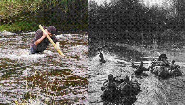
Figure 3: Wading fast and deep water.
Left: wading using a staff. Upper reaches of River Duddon, UK, mean discharge
5.1 m3/s. Courtesy of Paul Kirtley, Frontier Bushcraft Ltd, UK.
Right: Soviet machine gun crew wading in WWII.
Logically the hvc limit differentiates rivers and their reaches between those with an hv equal or greater than 1.32 m2/s that had to be crossed by bridge, boat, draining-trenches or swimming, and those with less than 1.32 m2/s that could have been waded. In addition, and following from the earlier discussion, the water depth must not exceed 1.25 m. For emphasis, in this essay it is proposed that the Keltoi swam a reach of a river of hvc greater than 1.32 m2/s and depth greater than 1.25 m: therefore finding all such reaches in SE England will place a semi-empirical limit on where the two-day river battle took place.
To examine these variables it was necessary to mathematically reconstruct the river width, height, velocity and discharge for all rivers in SE England for July, 43 AD.
The reconstruction of the non-tidal hydrology of SE England
The literature on the invasion in 43 AD contains comments on the physical parameters of rivers, usually water depth, and how they might relate to selected events; these observations, often cursory, of modern rivers are used to support an argument or point of view. This practice is inappropriate, as the parameters of modern rivers are significantly different to their counterparts in 43 AD.
Width, depth, velocity and a host of other natural river parameters are governed, via complex interactions, by the local and distant topography, geology, vegetation, animal activity and, of course, precipitation, run-off and ground-water discharge.
Human activity alters all of these parameters, such that a reach of a modern river in SE England will have a different width, depth, velocity, etc. in comparison to its ancient, natural self.
Human agency has been so pervasive that the Environment Agency (UK) estimates that less than 15% of UK rivers are natural today (Centre for Ecology and Hydrology (CEH)); there are almost certainly none in SE England. To quote further from the CEH:
The need to drain land, to protect it from
flooding, to control the flow of water for water supply or hydropower, or to
use the watercourses for navigation, fishing or recreation, have all imposed
change [on natural rivers] to a greater or lesser degree.
The rainfall in July 43 AD was probably comparable to the modern era (even when accepting the arguments related to the Roman Warm Period (Bianchi and McCave, 1999) and whether that resulted in slightly more or slightly less rainfall). Ground-water storage, however, may have been greater due to little extraction, reduced surface runoff due to larger forests and only rudimentary field drainage, all of which probably resulted in larger and more persistent ground-water discharge to the rivers. The overall result may have been river-discharge regimes that were less extreme, for both high and low values, than the present day. This would be particularly true for many of the chalk- and limestone-based, ground-water dominated rivers in SE England (for example the Test, Itchen and Kennet).
To generalise, many of the modern rivers in the SE of England are narrower, deeper, flow faster and convey water more efficiently than their natural equivalents, resulting in greater flow rates at peak discharge. Interestingly, the reverse is probably true for stretches of the chalk rivers used for recreational fishing, e.g. the Test and Itchen in Hampshire, where they have been managed to allow trout fishermen to wade at ease.
In summary, the parameters of modern-day rivers cannot and should not be casually retrofitted to events in 43 AD. Instead the parameters should be derived from first principles and suitable modern-day data; this is the task for the remainder of this section.
In outline, the task was to determine by calculation the natural channels created by the rivers of SE England in 43 AD and then fill these with the discharge for July 43 AD. This exercise derived discharge rates, depths, widths and velocities for all rivers at the time of the two-day river battle.
The mean annual discharge (a.k.a. average annual discharge) can be used to calculate the bankfull state of a river. The bankfull discharge is that which fills the main channel of a river to capacity; any additional discharge causes over-banking and the flooding of adjacent land. It is generally accepted by most hydrological agencies that the dominant or channel-forming discharge for a dynamically stable channel approximates to the bankfull discharge, i.e. that which determines the gross parameters of the channel, e.g. depth, width, meander sinuosity etc..
Hence, in this study the mean
annual discharge (Qannual) for the years 1961-2011 was calculated
using the catchment water balance method (Gustard et al, 1992) augmented by
calculations of the base flow index (BFI - see definition at http://www.ceh.ac.uk/data/nrfa/data/derived_flow.html)
to derive aquifer discharge to rivers. Mean annual precipitation data were
taken from the UK
Climate Projections study (UKCP09) and mean annual evapotranspiration data
from Trabucco and Zomer (2009) for the years 1950-2000.
For this study the derived Qannual value at Teddington on the Thames was 76 m3/s, while at the same location the long-term (1883-1985) measured value is 78.2 m3/s (Beran and Field, 1988). The latter results from point measurements made at Teddington; the former the result of a very large number of individual calculations throughout the drainage basin all accumulating at Teddington: the correspondence between 78 and 76 m3/s suggested the results of the hydrology calculations were plausible.
The bankfull variables depth, width, velocity and discharge for a half-hexagon channel shape were derived in the following manner:
Bankfull depth - derived
from a power function of catchment area, ![]() (following the findings instigated by Leopold
and Maddock, 1953).
(following the findings instigated by Leopold
and Maddock, 1953).
Bankfull width -
estimation of river widths in Google Earth at 61 points in SE England.
Allowance was made for human interference, e.g. averaging the width up and downstream
of weirs. These 61 values were regressed against Qannual
to give, ![]() ,
R2 of 76.49%. This equation was used to derive bankfull widths for
all rivers in SE England.
,
R2 of 76.49%. This equation was used to derive bankfull widths for
all rivers in SE England.
Bankfull velocity -
derived from the Manning velocity formula (a standard hydrological
method), ![]() where v is the bankfull velocity; k is 1.0
(metric conversion number); n is a roughness coefficient set to 0.07 for rivers
of width less than 30 m or 0.065 for greater, e.g. the Thames; R is the
hydraulic radius and S is the slope of the channel. The values for n were
relatively high compared to values assigned to the same modern-era rivers; this
reflected the wider and shallower nature of the ancient rivers and the greater
amounts of vegetation bordering and within the river.
where v is the bankfull velocity; k is 1.0
(metric conversion number); n is a roughness coefficient set to 0.07 for rivers
of width less than 30 m or 0.065 for greater, e.g. the Thames; R is the
hydraulic radius and S is the slope of the channel. The values for n were
relatively high compared to values assigned to the same modern-era rivers; this
reflected the wider and shallower nature of the ancient rivers and the greater
amounts of vegetation bordering and within the river.
Bankfull discharge - derived from the formula,
![]()

Figure 4: Scatterplots of
regression analysis for bankfull parameters. From left to right: bankfull
discharge plotted against: bankfull velocity, R2 90.51%; bankfull
depth, R2 93.07%; and bankfull width, R2 97.08%.
The correlation between bankfull discharge and other channel parameters was in all cases greater than R2 90% (Figure 4), even though different methods were employed to derive bankfull width, depth and velocity, i.e. the independently-calculated variables were statistically shown to be dependent and correlated. Furthermore, the modern-era greatest bankfull discharge at Kingston-on-Thames is 459 m3/s; for this study it was 436 m3/s, a reasonable correspondence given the computational uncertainties inherent in both numbers.
Having calculated the channel form for 43 AD the next step was to fill this with the discharge for July of that year, but which modern set of precipitation data would plausibly mimic that of July of 43 AD?
It was necessary that this study defined a convincingly plausible hydrological regime for July 43 AD, as to do otherwise would allow criticism of the flow for being too low. To that end, the precipitation in July for the years 1766 to 2011 (Simpson and Jones, 2012) was examined and the gridded data for July 2008 selected as that which most closely matched the mean minus one standard deviation (Figure 5).

Figure 5: Precipitation
exceedence curve for the years 1766 - 2011. Precipitation data for July
2008, the closest available gridded dataset, were selected as representative of
July 43 AD.
Figure 5 showed that there were 201 out of 251 years (80.16%) drier than July 2008. In emphasis, selecting July 2008 as a conservative proxy for July 43 AD meant that statistically the Romans would probably have actually experienced a drier July, with the rivers being narrower, shallower and slower than the calculated figures used in this study, i.e. the Romans would have found the rivers easier to wade.
The July 2008 precipitation values were processed as described above for the mean annual discharge, Qannual, to derive discharges for July AD 43.
As the bankfull parameters were
based on a half-hexagon cross-section then any decrease in discharge, i.e. in
July, would result in the river level sliding down the upturned side of the
half-hexagon giving a linear decrease in depth and width, while velocity would
also decrease as the relative proportion of frictional surfaces increased (the
sides and bottom of the channel together with any vegetation in the channel).
Both the Qannual and July discharges occupy the same channel form, the
half-hexagon, therefore the bankfull regression equations for depth, width and
velocity could be applied to the July case. The July discharge was the result
of ![]() (Figure 7).
(Figure 7).
Confirmation of the appropriateness of this approach is displayed in Figure 6 where velocity and discharge values for July were regressed against the bankfull discharge giving R2 of 90.01% and 98.54%, respectively. Further confirmation is displayed in Table 2, where modern-era discharge values for July and mid-Summer are compared to those calculated for July 43 AD; on the whole the 43 AD values were higher but this reflects the deliberate choice, described earlier, to select the mean minus one standard deviation for the precipitation values, i.e. the high values of 2008 as a surrogate for 43 AD.
 |
 |
||
Figure 6: Scatterplots of regression of velocity and discharge for July
against bankfull discharge. The graphs validated the half-hexagon and
regression technique employed to calculate depths, widths, velocities and
discharges for July 43 AD.
|
River |
discharge Rate (m3/s) |
Period Details |
Source |
|
Thames at Eynsham |
6.1 |
Mean June, July, Aug., reconstructed discharge |
Jones, et al (2004) |
|
Thames at Eynsham |
5.0 (approx.) |
July |
Haxton, et al (2012) |
|
Thames at Eynsham |
9.96 |
Mean July |
This study |
|
|
|
|
|
|
Kennet at Newbury |
3.0 (approx.) |
July |
Haxton, et al (2012) |
|
Kennet at Newbury |
4.1 |
Mean July |
This study |
|
|
|
|
|
|
Medway to Teston |
2.72 |
Mean June, July, Aug., reconstructed discharge |
Jones, et al (2004) |
|
Medway to Teston |
3.0 (approx) |
July |
Haxton, et al (2012) |
|
Medway to Teston |
3.6 |
Mean July |
This study |
|
|
|
|
|
|
Itchen to Highbridge |
5.37 |
Mean June, July, Aug., reconstructed discharge |
Jones, et al (2004) |
|
Itchen to Highbridge |
5.82 |
Mean July |
This study |
|
|
|
|
|
|
Great Stour at Horton |
1.5 (approx) |
July |
Haxton, et al (2012) |
|
Great Stour at Horton |
1.03 |
Mean July |
This study |
|
|
|
|
|
|
East Stour at South Willesborough |
0.2 (approx) |
July |
Haxton, et al (2012) |
|
East Stour at South Willesborough |
0.21 |
Mean July |
This study |
|
|
|
|
|
|
Lod at Halfway Bridge |
0.2 (approx) |
July |
Haxton, et al (2012) |
|
Lod at Halfway Bridge |
0.29 |
Mean July |
This study |
Table 2: Comparison of mid-Summer and July discharge rates, m3/s. See text for discussion.
However, it must be emphasised that calculating such figures, even for the modern era, is fraught with uncertainties, unknowns and computational difficulties. Furthermore, the figures should not be considered accurate of the actual discharge rates in 43 AD: such a computation is probably impossible and, even if it were not, the accuracy status could not be confirmed. The figures may be more correctly described as plausibly representative of a higher than the mean discharge rate in July of 43 AD, with a relatively small margin for error and climate variability.

Figure 7: The main rivers of SE England in July 43 AD. Only rivers with a mean discharge rate greater than 0.2 m3/s for July are shown. Tidal effects have not been computed for this map. The indicative width and colour of rivers are scaled according to their discharge rates. The Thames is the largest at greater than 50 m3/s at London. All rivers have different courses in comparison to the modern era, for example, the Rother in Kent is significantly different, and the Great Stour reaches the sea at Reculver having roughly followed the course of the modern North Stream (canalised course). These courses may reflect reality in 43 AD but they are defined by modern topography (source: SRTM, 90 m resolution), including geo-engineering of many kinds, and take no account of changes in land use, drainage or relative sea level. The blue coastline is modern and also shows the tidal range along river valleys.
One more hydrological parameter was required: the thalweg which is the line defining the lowest elevation points along a river. The thalweg is said to be estimated by the formula:
![]()
where depth is described as: "effectively the flow depth evaluated based on average bed level", (Melville and Coleman, 2000); the term 'average bed level' can be ascribed to the average depths calculated for July 43 AD. The thalweg, therefore, marks the maximum depth of a channel but it is not a constant 1.27 times deeper than the average depth; it varies considerably, being usually deeper at meander bends, where scour forces are greater, and shallower along straight reaches. The deepest thalweg can exceed 1.27 times the average depth but elsewhere be equal or less than the average. Furthermore, complex hydrological interactions in straight reaches cause the thalweg to shallow and deepen with a wavelength peculiar to that river or reach. This results in a series of pools (deep) and riffles (shallow), and the thalweg amplitude of the riffles can be less than the average depth value. As an example, the pools and riffles of the chalk trout streams of SE England have been augmented and maintained by human interference so that fly-fishermen can wade onto the shallow riffle and cast their lines above the deeper pools (Summers et. al.,1996). The general point is that the thalweg is extremely variable for any river or reach and, pertinent to this study, can approximate to the average river depth. The latter observation is well-known and may have been exploited by the Romans seeking to wade in 43 AD, i.e. avoid the most acute meander bends, where the deepest thalweg was likely to occur, but instead search the longest reaches for the shallowest water. In that sense, therefore, the thalweg was a porous barrier, i.e. an inconvenience to an army seeking to cross by wading rather than an absolute barrier, such that including it in this study could be considered an over-elaboration; an unnecessary distraction from the average depths already calculated for July 43 AD. However, its inclusion allows for a more plausible examination and eventual discussion of the likelihood of a particular reach being the site of the two-day river battle.
Combining hydrology with wading limits
To summarise the previous section, thalweg values greater than 1.25 m in depth and hv exceeding 1.32 m2/s were described as offering a porous barrier to waders, but the same numbers for the average July computations were considered absolute barriers. The thalweg and average numbers could now be examined to separate rivers into those that could have been waded and those that had to be swum. (Note: the numbers and resulting observations in this section relate solely to river hydrology and do not include tidal information which will be discussed later.)
This examination is best displayed in maps (Figures 9, 10 and 11); Table 3 shows the maximum water depth and the instability index (hv) only for rivers of any numerical significance, namely, the Thames, Kennet, Wey, Medway, Arun, Itchen and Test (locations in Figure 8).
Referencing these maps, the first observation was that the average water depth for some reaches could exceed the 1.25 m limit but with an hv lower than the 1.32 m2/s limit. In these situations the river was flowing deeply but slowly (compare the upstream extent of the Thames and Test in Figures 9 and 10).
A second observation was that the average depth map showed that only the Thames and Test would have formed absolute barriers (Figure 9, left) to wading Roman legionaries. Dio tells us that the Thames was not the site of the two-day battle as it was crossed after its conclusion, and the author is not aware of any previous worker advocating the Test, presumably because a battle west of Chichester or Fishbourne would then have required a long and convoluted march to bring the protagonists to the banks of the tidal Thames. Also, Dio's account of Roman units pursuing the fleeing British forces immediately after the battle implies, but does not explicitly state, a short distance between the site of the two-day battle and the skirmishes at the Thames where:
it empties into the ocean and at flood-tide forms a lake.
The same observations may also be applied to the Itchen which only appeared as a porous barrier in the thalweg maps. Therefore, certainly the Thames, and probably the Test and Itchen, could be discarded as candidates for the two-day battle.
Further observations related to the nature of the porous barriers evidenced on the maps for the Kennet, Wey, Medway, Arun, Itchen and Test (Figures 9 and 10, right).
The Kennet in its lower reaches had a maximum thalweg of 1.49 m at its confluence with the Thames and a thalweg hv of 1.59 m2/s; both values could be considered high and indicated that the Kennet, although not an absolute barrier, would have caused the Romans considerable inconvenience in finding wading points. However, these observations may be moot, as the author is not aware of the Kennet being put forward as a possible site for the two-day battle.
In contrast, both the Wey (Bird, 2000) and the Arun (Hind, 1989 and 2007) have been mentioned as possible sites for the battle; neither had an average or thalweg hv greater than 1.32 m2/s but their maximum thalweg depths were 1.29 and 1.28 m, respectively (Figure 9 and Table 3). The Wey's maximum thalweg occurred at its confluence with the Thames which meant that river reach would have been a weak porous boundary in 43 AD, troubling the Romans hardly at all and suggesting that the British tribal commanders would have been incompetent to think otherwise. It was very unlikely that the Wey was the site of the two-day battle. The Arun's thalweg increased from 1.2 m at Pulborough, a suggested site for the battle, to 1.28 m (Figure 9 and Table 3) as it entered the sea (note: this is not the same location shown on modern maps; the Arun is one of the most engineered rivers in SE England). Thus the Arun could be classified as porous but not as far inland as Pulborough, and so that location was very unlikely to have been the site of the two-day battle.
In passing it should be noted that the Mole (Figure 7), another river that has been mentioned as a possible battle site (Bird, 2000), had values of depth and hv that meant it would have been waded with ease. Thus the Mole was extremely unlikely to have been the site of the two-day battle.
The hv for the Medway never exceeded 1.32 m2/s for either the average July depth or the thalweg, and the only barrier to wading was the thalweg depth, maximum 1.32 m just beyond modern Rochester (Figures 9, 10, 11 and Table 3). Therefore the Medway, like the Arun, was a porous barrier and also has been extensively re-engineered.

Figure 8: Average depth of
water for rivers in July 43 AD. Only depths greater than 0.5 m are shown.
No tidal information is included. See Figure 7 for river locations.

Figure 9: Average depths (left) and thalweg depths (right) greater than 1.25 m in July 43 AD. In this study an average depth of 1.25 m was considered to be an absolute barrier to wading - Thames and Test. However the thalweg depths, being variable due to river dynamics, would have created a porous barrier, readily penetrated - Kennet, Wey, Medway, Arun, Itchen. See Figure 7 for river locations. Rivers north of the Thames are thought not pertinent to this study.

Figure 10: Instability index (hv) greater than 1.32 m2/s for average river depth (left) and thalweg depth (right) in July 43 AD. In this study an average July instability value of 1.32 m2/s was considered to be an absolute barrier to wading - Thames and Test. However the thalweg instability, being variable due to river dynamics, would have been a porous barrier, readily penetrated - upper reaches of the Thames and Test, lower reaches of the Kennet and Itchen. See Figure 7 for river locations. Rivers north of the Thames are thought not pertinent to this study.

Figure 11: River reaches acting as absolute (red) or porous (blue) barriers to wading in SE England in July 43 AD. Absolute barriers were the lower reaches of the Thames and Test; porous barriers were the upper reaches of the Thames and Test and the shown reaches of the Kennet, Wey, Medway, Arun and Itchen. Rivers north of the Thames are thought not pertinent to this study.
|
Maximum Depth and Instability |
Thames |
Kennet |
Wey |
Medway |
Arun |
Itchen |
Test |
|
River depth - average (m) |
1.96 |
< 1.25 |
< 1.25 |
< 1.25 |
< 1.25 |
< 1.25 |
1.35 |
|
Thalweg depth (m) |
2.49 |
1.49 |
1.29 |
1.31 |
1.28 |
1.46 |
1.72 |
|
Instability - river depth av.( hv) |
2.86 |
< 1.32 |
< 1.32 |
< 1.32 |
< 1.32 |
< 1.32 |
1.53 |
|
Instability - thalweg ( hv) |
3.64 |
1.52 |
< 1.32 |
< 1.32 |
< 1.32 |
1.48 |
1.94 |
Table 3: Maximum depths (m) and Instability Indices (hv [m2/s]) for the average and thalweg depths for the rivers in SE England that were absolute or porous barriers to wading Roman legionaries. Numbers preceded with a less than (<) symbol were below the chosen limits of 1.25 m water depth and 1.32 instability index (hv). Tidal conditions have not been applied to the Thames, Medway, Arun, Itchen or Test (see section below for tidal observations).
The main findings of this section were that:
1) only the Thames and Test formed absolute barriers. However the former, according to Dio's account, was not the site of the two-day battle. The latter could not be completely eliminated as a candidate battle site but it was an unlikely possibility as the river was far to the west
2) similarly, the Itchen was too far to the west, a porous barrier and not a candidate battle site
3) neither the Wey nor the Mole were likely to have been the site of the two-day battle
4) based solely on their river hydrology, i.e. excluding tidal effects, neither the Arun nor the Medway were likely to be candidate battle sites.
Therefore the main conclusion of this section is that it is very unlikely that any of the rivers in SE England were the site of the two-day battle, but this is only acceptable if tidal effects are excluded. If tidal considerations are included then only the Medway and Arun can be considered as candidate sites. These will be individually examined after the next section on the tidal regimes in 43 AD.
Tidally influenced rivers in 43 AD
The tidally-influenced rivers in 43 AD would have been very different to those in the modern era because of human agency and post-glacial, relative sea-level changes.
For centuries the estuaries and tidal reaches of all rivers in SE England have been altered, to varying extents, typically in an effort to reclaim land and/or enhance the carrying capacity of the river for either flood-relief or transport. In their natural state in 43 AD most rivers in SE England approached their estuaries as a single channel, much as they do today. But the estuaries then were very different, with a main channel often accompanied by tidal sub-channels separated by mud-flats and salt-marshes, i.e. a wide, low-lying, tidally-dominated landscape with multiple channels, many of no great depth. Today, after centuries of engineering works and draining of marshes etc., most of the ancient estuarine land has been claimed as farmland, with a single tidal channel flowing within. Furthermore, the tidal effects within the modern channels often extend far inland (Figure 12), much further than the natural flow in 43 AD.

Figure 12: Modern-era coastal boundaries showing the extent of inland tidal influence. The Thames is tidal to Teddington Lock, the Medway to Maidstone, the Great Stour to Fordwich (east of Canterbury), the Adur to Shermanbury and the Arun to Pallingham Quay, a distance of 22km. See Figure 7 for river names. Roman roads (purple) join towns etc. Acknowledgement: Contains Ordnance Survey data © Crown Copyright and database right, 2014.
This is because in 43 AD the extensive mudflats and many channels caused the tidal inflow to greatly dissipate within the estuary, with only a small part of the tidal prism giving rise to greater depths further inland along the main channel. Since that time engineering works have deliberately extended the tidal range for the purposes of commerce.
The human-induced changes to the natural regimes have been augmented by post-glacial alterations in relative sea-levels. Given that the eustatic sea-level has been broadly constant over the last four thousand years (Peltier, 2002), known as the mid-Holocene high stand, then these alterations are largely due to: isostasy; tectonic re-adjustments (minor); changed coastlines resulting in altered tidal prisms; and de-watering and compaction of sediments. It is beyond the scope of this essay to describe these mechanisms with the exception of generalised comments on the changing coastline in SE England since the Roman period (Figure 13).
Figure 13 shows a Roman era coastline significantly different to today's. It was more intricate and indented, with longer sand and gravel spits embaying large lagoons and, of course, the coastline extended further out to sea, all of which would have altered the tidal regimes operating within the rivers. The temporal differences are not just erosional, as sedimentary deposition has also played its part. Thus the Isle of Thanet is no longer an island as the Wantsum channel between Reculver and Richborough has silted up; likewise the lagoons between Deal and Sandwich, Pevensey Bay and Romney Marsh; and the former tidal inlet at Dover is no more.

Figure 13: The Roman coastline of East Sussex and Kent. Map courtesy of Dr. C. Moses, Beaches At Risk (BAR) Project, Interim report, January 2005. The original BAR text is: "BAR researchers have prepared this map using archaeological and geological data as well as cliff retreat rates calculated from historic maps. Despite many uncertainties, it is clear that the coastline in Roman times was more intricate than at present, with larger tidal estuaries and bays. Coastal cliffs extended further out to sea, making France and England even closer neighbours. Beach shingle is likely to have been more plentiful."
Much understanding of relative sea-level change has accrued over the last two decades, and has resulted in regional maps such as Figure 14. Here the broad scale and extent of the relative rise and fall of the British landmass is apparent. This map shows that the SE of England has experienced a negative mean relative sea-level change, i.e. the land has lowered relative to an approximately constant sea-level during the Late Holocene and, by implication due to compatible date ranges, since the Roman invasion in 43 AD.

Figure 14: Late Holocene (last
4,000 years) mean relative sea-level changes (mm/yr). Positive values
indicate the land has risen relative to the sea-level, negative the opposite.
Values in parentheses indicate modelling of local tidal ranges. Red values in
square brackets are relative sea-level changes in metres for SE England since 43
AD. Note that no allowance has been made for the compaction of local sediments.
Primary source: Updates to regional net sea-level change estimates for Great
Britain, UK Climate Impacts Programme, 2007. Secondary source: Shennan and Horton, 2002.
Since 43 AD the land has fallen relative to the sea by 1.41 m in the London and north Kent regions; 0.8 m on the SE coast (around Eastbourne and Hastings); and 1.2 m in the Solent region. With higher relative land in 43 AD the tidal prisms may not have travelled as far inland as they do today, but precisely calculating by how much less is difficult because there are many unknown ancient factors that otherwise influenced the ebb and flow.
However, there are other historical sources of tidal information and these will be used to describe the only remaining candidate rivers, the Arun and Medway.
The Arun of West Sussex
The purpose of this section is to discover if the non-tidal porous reaches of the Arun can, in combination with the tidal reaches, remain as a plausible candidate battle site.
The BAR Project map (Figure 13) shows that the Roman coast at the mouth of the Arun extended approximately 3-4 km further south at Littlehampton than it does today. This low-lying land probably consisted of mud-flats, salt-marshes and numerous channels, all protected by sand-shingle-gravel spits and barriers aligned sub-parallel to the coast. Its removal may be due to two mechanisms. Firstly, over the two thousand years the west-to-east prevailing winds, together with the tidal ingress to the English Channel, have driven erosional waters which have removed large quantities of material eastwards. Secondly, and possibly the dominant coastal erosion mechanism, the beaches were driven progressively landward by continuing relative sea-level rise and storm activity, all of which resulted in the diminished coast we see today (SCOPAC, Pagham to Adur). Another result of the west-to-east wind regime, coupled with a lack of any form of rocky headland or resistant islands, is the straight form of the coast, both Roman and present (Figure 13). Consequently there existed no significant mouth to the estuary into which the tidal prism was funnelled, resulting in a relatively feeble tidal inflow into the Arun.
Another consequence of this considerable erosion is that the mouth of the Arun has migrated both east and west of the current man-made mouth at Littlehampton. For example, some authors state that before the 15th century the Arun shared an estuary at Lancing with the Adur, some 15 km east of its present location. However, this appears to be conjectural and is disputed by others (Brookfield, 1952). Nevertheless, for the purposes of this essay, this argument is indicative of the nature of the eroding coastal plain, with many temporal features unknown and probably unknowable. Later, firm evidence for the mouth of the Arun being at Littlehampton is displayed in the Armada Survey map of 1587.

Figure 15: Topography and location map for rivers Arun and Adur, West
Sussex. For the Arun the red colour marks the probable tidal limit in 43
AD; black reaches were porous to the Roman army; all yellow reaches offered no
barrier to wading Romans. The coast is that of the present day, not that in 43
AD which would have extended some 3-4 km further offshore (Figure 13).
The town of Arundel is situated at the southern end of the gap in the South Downs excavated by the Arun and is today approximately 6 km from Littlehampton; in 43 AD Arundel was 9-10 km from the sea. Within this 9-10 km of low-lying, marshy, flood-prone and estuarine land ran the tidal Arun before it entered its estuary proper. As already discussed, here the tidal flow would probably have been greatly attenuated within creeks, channels and mud-flats, leaving significantly less available energy, in comparison to today's regime, to flow far inland. Couple that with the 1.2 m higher elevation of the land and the flow would have been even further restricted in its inland extent. But by how much, and were there any wadeable stretches? The answers are available if navigational improvements of the river are examined backwards in time.
Today the Arun is tidal to Pallingham Quay, a distance of 22 km, but in 1785 the tidal limit was at Houghton Bridge, 11 km from the coast (Table 4). In the 16th century Henry FitzAlan, Earl of Arundel, made that town a port for sea-going vessels. By 1547 his efforts improved the river to North Stoke which may have marked the tidal limit. The Doomsday Book reported that Arundel had a port in 1086 and this is thought by some authors to have been at Ford, indicating that it might have been the tidal limit. Ford is 3.25 km south of Arundel and approximately 2.75 km from the present coast. It has a Saxon church (St. Andrew by the Ford, built in c.1040) and, based on its name, marks a point where the Arun could have been waded, i.e. it shallows where elevated land pinches the river valley and may have formed a barrier to tidal ingress. Whether this was true in 43 AD cannot be ascertained but it does seem likely, which would place the tidal limit in 43 AD at c. 6-7 km from the sea. Circumstantial archaeological support for this may be provided by the abandonment of an approximately 1st century Roman villa at Arundel, as navigational difficulties are thought to have been the possible reason (SCOPAC, 2006).
|
Location |
Dates for the location of the tidal limit |
Present distance to sea (km) |
Distance to sea, 43 AD (km) |
River depth av. July 43 AD (m) |
Thalweg depth July 43 AD (m) |
Instability index - thalweg, 43 AD (m2/s) |
|
Pallingham Quay |
Present |
22 |
26 |
0.78 |
0.99 |
0.77 |
|
Pulborough |
Not known |
18.5 |
22.5 |
0.97 |
1.23 |
1.1 |
|
Houghton Bridge |
1785 |
11 |
15 |
0.98 |
1.25 |
1.14 |
|
North Stoke |
1547 |
10 |
14 |
" |
" |
" |
|
Arundel |
Not known |
6.5 |
10.5 |
0.99 |
1.26 |
1.15 |
|
Ford |
1086 and 43 AD |
2.75 |
6.75 |
1.01 |
1.29 |
1.19 |
|
Littlehampton (mouth) |
Not known |
0 |
4 |
1.01 |
1.29 |
1.19 |
Table 4: Statistics for points
on the river Arun. The distance figures (km) are straight-line values to
the appropriate coast, not the distances that the meandering Arun does, or did,
take. The latter, of course, cannot be substantiated. In essence, the presented
distances can be thought of as military 'fronts'. Note that the average river
depth nowhere exceeded the 1.25 m wading limit and the thalweg depth only just
exceeded this limit at Arundel. Nowhere on the river was the critical
instability index value of 1.32 m2/s exceeded (tide values not
included).
In summary, the Arun may have been tidal to Ford, a distance of c. 6.75 km, been a porous barrier to wading Romans from Ford to just north of Houghton Bridge and, from that point north, readily waded by Roman legionaries (Figure 15). Only the tidal reach south of Ford might have required the Keltoi to swim.
Hence, and in support of an earlier fluvial finding, the postulated site of the two-day river battle at Pulborough can now be dismissed as a possibility, there being no reason why the Keltoi would have had to swim the Arun there; indeed, the river could have been easily waded by legionaries.
Probably the only area that the British tribesmen could have thought defensible, or a platform from which to combat the Romans, is the South Downs east of the Arun between Arundel and Houghton Bridge (Figure 15). However, the Arun was porous in this stretch as far south as Ford, probably could have been waded at various points and, as Figure 15 shows, offered no resistance to wading northwards, allowing the Romans to easily flank and trap the British against the low-lying marshy ground and coast to the south. Indeed, although swimming Keltoi may have been required south of Ford, the reaches north as far as Arundel together with the flat low-lying ground, would have been porous to legionaries, allowing them to wade across and attack the British southern flank situated on the downs: swimming Keltoi would have been tactically superfluous. In addition, a viewshed analysis (Figure 16) of the Ford location shows that any Roman unit may have been visible to the British from many points on the South Downs, and probably would not have had any element of surprise. The same is true for movements in the Arundel area (not shown). Of course, if the Roman units were operating at night, or moving within woods, then they may have been unobserved.

Figure 16: A viewshed analysis from Ford. Ford would not have been
visible in the pink areas. All crossing-points, swimming or wading, from Arundel
downstream to the modern coast, would have been visible in daylight to the
British located on the high ground of the South Downs. Note that this viewshed
does not account for Roman units operating within woods or at night.
In a tactical sense, the South Downs position, or its margins, was a trap for the British, being easily flanked by wading legionaries from the north and south and neither direction would have required the Keltoi to swim the Arun.
Furthermore, we know that the British had many chariots from which the senior warriors and leaders fought. Earlier examples of these have been reconstructed and tested (Loades, 2005). They were two-wheeled, two-horsed fighting platforms of lightweight construction, rapid in movement, quick to manoeuvre and probably used as javelin platforms where the vehicle, with a driver and another, would approach the enemy line, launch javelins and then wheel away before repeating the process. This usage would have required horses with considerable stamina. Undoubtedly they would have operated best on open, grassy, relatively flat or slightly sloping ground as some undulation in the topography would have slowed their progress. It is hard to conceive of a reason, other than incompetence, for selecting the South Downs as a battle ground, given that the highest ground is a very thin ridge, often only c.100 m wide, up to which many steep-sided valleys ascend. On this terrain, repeated javelin attacks on the Romans would have quickly tired the horses and partially negated the effectiveness of this weapon; a similar argument can be made for any light cavalry in the British force. In topographical contrast is the North Downs west of the Medway (Figure 17): here the elevated back-slope of the escarpment is relatively flat, broader and more open with lower gradients, altogether more suited to chariot warfare than the South Downs east of the Arun. However, it should be emphasized that neither location represents the best surface for chariot operations; the distinction made here between the two is one of degree.
In conclusion, it can be stated that the river Arun north and south of the South Downs could have been waded by legionaries without the requirement of swimming Keltoi, and that it is very unlikely, barring British incompetence, to have been the site of the two-day river battle.
The Medway of Kent
Leaving aside tidal considerations and comparing Tables 4 and 5 respectively for the Arun and Medway, reveals that both fluvial rivers were benign to wading Romans in 43 AD. Neither had an average river depth in July that exceeded the wading limit used in this study (1.25 m), i.e. they were not absolute barriers. Maximum thalweg depth for the Medway was 1.31 m and 1.29 m for the Arun, i.e. both were easily porous to the Roman army. Finally, neither river had an instability index, hv (m2/s), that exceeded the limit to wading, hvc, used in this study, 1.32 m2/s.
However, the tidal regimes in the two rivers were very different.
|
Location |
Tidal limit in - |
Present distance to sea (km) |
Distance to sea 43 AD (km) |
River depth av. July 43 AD (m) |
Thalweg depth July 43 AD (m) |
Instability index 43 AD - thalweg (hv) |
|
Mouth |
Not known |
0 |
0 |
1.03 |
1.31 |
1.23 |
|
Rochester Bridge |
" |
3 |
3 |
1.02 |
1.3 |
1.2 |
|
Cuxton |
" |
6.4 |
6.4 |
1.01 |
1.29 |
1.19 |
|
Halling |
" |
8.8 |
8.8 |
1.01 |
1.28 |
1.19 |
|
Snodland |
43 AD ? |
10.8 |
10.8 |
1.0 |
1.28 |
1.18 |
|
Aylesford |
43 AD ? |
12.1 |
12.1 |
0.99 |
1.26 |
1.15 |
|
Allington Lock |
Present day |
12.7 |
12.7 |
0.99 |
1.26 |
1.15 |
|
Maidstone |
Not known |
14.6 |
14.6 |
0.98 |
1.25 |
1.14 |
|
East Farleigh |
c. 1798 |
16.5 |
16.5 |
0.96 |
1.22 |
1.09 |
|
Teston |
NA |
18.1 |
18.1 |
0.96 |
1.22 |
1.09 |
Table 5: Statistics for points
on the river Medway. The distance figures (km) are straight-line values to
the mouth, not the distances that the meandering Medway does, or did, take. The
latter, of course, cannot be substantiated. In essence, the presented distances
can be thought of as military 'fronts'. Note that the average river depth
nowhere exceeded the 1.25 m wading limit but the thalweg depth exceeded this
limit at all points north of Maidstone. Nowhere on the river was the critical
instability index value of 1.32 m2/s exceeded (tide values not
included).
The present-day river Medway (Figure 17) passes into a macro tidal estuary with a spring tidal range of 5.1 m at Rochester; at Allington Lock, which is the tidal limit, the range is 3.4 m at springs and 2.4 m at neaps (Halcrow, 2010). Significantly, the North Sea tidal body propagates southwards and is amplified by funnelling and shallow water effects such that, as it enters the Medway channel, it increases in amplitude when tidal reflection sets up a standing wave whose amplitude increases towards the landward end of the channel between Snodland and Allington Lock (IECS, 1993).
One consequence of this increasing amplitude is that the inner reach, Rochester to Allington Lock, (Figure 17) is ebb-dominant - the tide flows out faster than it flows in - with a narrow, meandering channel (Halcrow, 2010).
In modern times this landward increase in amplitude has been exacerbated by extensive reclamation of tidal flats and salt marsh in the original multi-channel mouths around the Isles of Grain and Sheppey. It is thought this reclamation was begun in the Roman era (IECS, 1993).
The main point to be taken from these opening paragraphs is that the present-day river Medway is strongly tidal as far as Allington. Earlier, Hasted (1798) reported that the Medway was tidal to East Farleigh (Figure 17). However, this was after navigational works to Tonbridge, allowed by a 1740 Parliamentary Act, and cannot be claimed as the natural tidal limit. The question, therefore, is would this broad tidal-regime have pertained in 43 AD when the relative sea-level was 1.4 m lower? The topography of the estuary and river-valley hold some clues.

Figure 17: Topography and
location map for the Medway, Kent. The red colour marks the possible tidal
reaches in 43 AD; black reaches were porous to the Roman army; all blue reaches
offered no barrier to wading Romans. The coast is that of the present day, not
that in 43 AD (see Figure 13).
Today, the estuary is topographically-dominated by the Hoo peninsular and the Isle of Grain in the west and the Isle of Sheppey in the east (Figure 18), and between these land masses can be found the main entrance to the river Medway. In 43 AD, before the extensive land-reclamation began, there were two entrances to the Medway: the present-day entrance between the Isles of Grain and Sheppey, and the other to the west of the Isle of Grain. Consequently the total entrant area was much larger in 43 AD, thereby allowing more of the open-sea tidal bulge to move into the estuary. Additionally, in 43 AD the amount of land beyond the entrances was much less than today, suggesting that the inflowing tide would have been less dissipated than today and would have had a greater energy once it had reached the Rochester environs. It should be noted that unfortunately Figure 18 only shows the eastern side of the estuary and that the author has failed to find a comparable map or report detailing the western side but, as this area mostly contains the Hoo Peninsular which has always, during the period of discussion, been directly connected to the mainland, the loss is not detrimental to the discussion.

Figure 18: Tidal entrance to
the Medway in 43 AD (black) and the present-day (red). Map courtesy of Dr.
C. Moses, Beaches At Risk (BAR) Project, Interim report, January 2005.
Continuing with topography, it can be stated that the river has not changed location at Rochester since c.43 AD: while building the existing bridge in the 1850s the old Roman bridge foundations may have been uncovered. Today at Rochester Bridge the high water width of the river is c.190 m; seaward at Upper Upnor (Figure 17) it has broadened to c.350 m and, within 2 km further seaward, is beyond 1 km wide. At these points in 43 AD the river would probably have been wider but not excessively so, bounded, as we have discussed, by common topographical features.
South of Rochester the river is constrained by a narrow valley - the Medway Gap - created by the river as it down-cut through the chalk during eustatically-induced sea-level falls.
The topography in 43 AD, therefore, from the open sea to the inner reach was not very different in its gross form to that of today. Consequently it may be claimed that the landward increase in the tidal standing wave probably existed then and that the tide flowed at least beyond Rochester into the inner reach. The depth and landward extent of this wave, of course, would have been diminished by the then 1.41 m higher land elevation but, by how much cannot be described without extensive, and ultimately poorly controlled, calculations.
Nevertheless, some indication of the tidal state of the river in 43 AD may be gained from examination of the history of the crossing points between Rochester and Maidstone. Patrick Thornhill (1974) examined the geology of the inner reach via borings and studies of alluvium; his view was that in the Roman period the lower crossing at Holborough had been abandoned for that further upstream at Snodland (Figure 17). Within the river at Snodland occur the Snodland Rocks, a band of iron-cemented conglomerate which give a firm crossing point, visible today at low tide. Whether the abandonment of Holborough was due to an excessive tidal regime cannot be stated with absolute conviction. However, prior to later engineering works, it seems reasonable to conservatively state that the tidal limit within the inner reach in 43 AD lay between Halling and Aylesford (Figure 17). In Figure 17 the tidal limit (red line) is placed at a point south of Snodland where the river is pinched by east and west topographic highs and joined by a tributary, the Leybourne Stream.
To this discussion of tidal extent and depth a complication must be added. As the river is and probably was, ebb-dominated, the tidal component of the river depth would have been intermittent twice-daily leaving just the average July water depth or some level of thalweg depth (Table 5). This implies that even the tidal river may have been porous to wading legionaries twice a day, for one or two hours. Of course, some means, such as a corduroy of logs, might have been needed to be placed over the muddy embankments before crossing, but this would not have troubled the 'engineers' in a Roman army. Therefore, the red line in Figure 17 may not form an absolute wading-barrier but instead a tidally-determined porous barrier, possibly as far north as Cuxton where the average July water depth was only 1.01 m deep. Which, of course, begs the crucial question for determining the site of the two-day river battle: on which reach of the Medway might the Keltoi have had to swim?
If the British intent was to hold the ground to the west of the Medway and gain an advantage in battle by opposing as the Romans crossed the river, then the tidally- and fluvially-porous reaches south of Rochester are plausible locations. To be clear, and leaving aside the question of British incompetence, they thought the Romans could wade upstream of Rochester but not, at some point governed by prudence, further seaward. In which case the Keltoi may have taken the British by surprise by swimming the river at such a point, possibly in the area of Upper Upnor, where the river and estuary start to widen considerably. Figure 19, a viewshed analysis from Upper Upnor, suggests that this area may not have been within the British line of sight from nearly all locations west of the Medway, unless the observer was on the heights immediately west of Upper Upnor. Thus a hidden move to the river, followed by a swift swim by the Keltoi would, if they were only observed locally, have left little time for the British commanders to amass an opposing force. Note that this situation is in complete contrast to the situation on the Arun, where all Roman movements would have been seen from the elevations on the South Downs (of course, the assumption is that these were daylight movements and not hidden in woods).

Figure 19: A viewshed analysis from Upper Upnor. This location would not
have been visible in the pink areas. Only a British observer on the high ground
to the immediate west of the Medway would have seen any movement. In all other
locations the British would have been blind to a unit swimming the river at Upper
Upnor. Note that this viewshed does not account for Roman units operating within
woods or at night.
As an aside, if the move by the Keltoi was undetected until late in the event then this might be reflected in Dio's account:
instead of shooting at any of the men they
confined themselves to wounding the horses that drew their chariots; and in the
confusion that followed not even the enemy's mounted warriors could save
themselves.
A late detection by the British might have required a rapid reinforcement of the area opposite the Keltoi, in which case, the swift chariots might have been the first to arrive and they bore the brunt of the fighting as reflected - possibly - in Dio's writing.
For all points upstream of Upper Upnor there must have existed some level of doubt, in prudent British minds, about whether the Romans could wade or not; only in the area of Upper Upnor or further seaward would they have thought themselves safe from wading Roman units.
This would have given the British a front, from Upper Upnor to Snodland, of approximately 11 km to guard and contest any wading Roman units. South of Snodland the British would have expected the Romans to easily wade the river, in which case their most likely battle strategy would have been to withdraw from the Medway to the elevated ground between Platt Hill Wood and Crookhorn Wood which was protected to the south by the steep gradient of the North Downs escarpment (Figure 20).
In summary, it is found that the river Medway was the only river in the southern UK, an area bounded by the absolute barriers of the Thames and Test, that would have required the Keltoi to swim under the circumstances described by Dio. Therefore, the Medway probably was the site of the two-day river battle.
The Roman line of approach to the Medway
Given that the Medway probably was the site of the two-day river battle, then attempting to discover the probable approach direction by the Roman army might lead to insights into the location of the invasion landing-site.
Earlier work - on marching Roman armies, general rules on the placing of marching camps, the required amount of water in adjacent rivers and the marching rates of Roman soldiers - provides factors that can be applied to assist in finding the most likely approach route prior to the river battle (Kaye, 2013b and c).

Figure 20: Location map for
Kent. The white areas are those most suitable as locations for temporary
marching camps for the invasion army. The rivers (blue) are those that could
supply sufficient water for the Roman army, 0.02968 m3/s. The
elevation data displays the current coastline; the red coastline is for 43 AD
(source: Beaches At Risk (BAR) Project, Interim report, January 2005). The
red-brown stipple or patches in The Weald and much of the North Downs denotes
'ancient woodland', described as land covered by woods since 1600 AD (source:
Natural England, copyright acknowledged). The black lines are post-invasion
Roman roads.
As discussed earlier, the invading army is thought to have been four legions in size and with a similar complement of auxiliaries. An army of this size would require a marching camp similar to that of Logie Durno in Scotland and have a water requirement of 0.02968 m3/s (repeat of Table 1, below).
|
Attribute |
Value |
|
Length of minimum side |
653 m |
|
Length of maximum side |
959 m |
|
Area |
58.6 hectares |
|
Number of soldiers (legionaries and aux.) |
40,434 (at a density of 690 men/hectare) |
|
Number of camp occupants (soldiers plus others) |
52,437 |
|
Number of mules |
10,108 |
|
Number of horses (for the legions alone) |
1,895 |
|
Required fodder (hay or cut grass) |
120
metric tonnes per day |
|
Daily water requirement (beasts and humans) |
0.02968
cubic metres per second |
Repeat of Table 1: Statistics for the temporary marching camp at Logie Durno in Aberdeenshire (details of the calculations in Kaye, 2013b). The army that occupied Logie Durno was comparable in size to the invading army of 43 AD. Numbers for occupants are based on a density of 690 soldiers per hectare.
Figure 20 shows only those rivers capable of supplying the Roman army with the water required by all the humans and animals. The white areas in Figure 20 are those that are statistically the most favourable ground for marching camps the size of Logie Durno, have sufficient adjacent water and can be fitted into the available land between rivers and streams (Roman marching camps in the UK rarely have streams running through them). Details of the methods employed, the statistical work and reasoning can be found in Kaye, 2013b. One of the critical observations in that essay was that of the 307 camps, 23.78% receive their total water demand within 50 metres of the ramparts, 37.46% within 100 metres, 63.84 within 200 metres and 78.16% within 300 metres (Figure 21): the Roman army habitually placed its marching camps next to rivers for reasons of water supply and defence.

Figure 21: Histogram of distances to the river(s) that totally supply the marching camp demand. Of 307 UK-wide marching camps examined, 23.78% received their total demand within 50 metres of the ramparts, 37.46% within 100 metres, 63.84 within 200 metres and 78.16% within 300 metres (Kaye, 2013b).
Typically Roman armies moved as one mass, all units moving in unison between marching camps or towns and forts. Exceptions were made, for example during Agricola's campaign in Scotland when he separated the Ninth Legion which resulted in a night-attack by tribesmen on the Ninth's marching camp that was almost successful (Tacitus, Agricola, 26). This episode demonstrates one reason why Roman armies marched as a single unit. In 43 AD Dio tells us that, prior to the two-day river battle, the Romans separately defeated Caratacus and then Togodumnus, but we are not told whether these actions required a separation of the Roman army units, or the British leaders contested the route of the whole Roman army. Therefore, not knowing these specific details the rest of this account will assume the Romans marched as a single unit, i.e. the normal Roman operating procedure.
As many writers have done before, it seems plausible to assume that the invasion landing ground was somewhere east of the Rochester-Maidstone battle front. If this was case, Figure 20 (the white areas) shows only two approach lines the Roman army could have taken: north or south of the North Downs; the northern follows the axis Rochester-Sittingbourne-Faversham-Canterbury (henceforth the north-Downs route); the southern takes the axis Maidstone-Ashford-Canterbury (henceforth the south-Downs route). Please note that the Roman roads shown in Figure 20 are post-invasion and are only shown to aid the viewer; they may mark the position of ancient trackways, either in totality or partially, but this cannot be relied upon and, in any case, a trackway was a poor conduit for marching Roman armies.
Knowing where the most favourable
marching camp ground was located does not imply that the whole Roman army could
have easily marched to that location in a day. The practice of moving large
bodies of humans and animals was complex, in part governed by the marching
surface and terrain, e.g. gradients, by the reliance on food and water and, of
course, the need for formation defence. For example, the Roman road system was probably
designed to allow the passage of two, possibly three at most, legions of
soldiers marching in a single column; a greater number required the army to
march in multiple columns, whether a road existed or not. Hence, the invasion
army would have marched in multiple columns and, because the safe assumption is
that there were no roads available, off-road at a velocity within the range 0.6706 m/s (1.5 mph, 2.41 kph) to 0.7639 m/s (1.71 mph,
2.75 kph), (Kaye, 2013c, re. this paragraph).
However, a velocity figure alone was not sufficient to calculate the distance covered or time of transit, in this case from one marching camp to another. What was also required were calculations on such things as: the way in which the army exited the morning-camp; the form of the marching columns; the structural details of the columns, e.g. rank and file numbers for men, horses and mules; and the calculations of time spent on all the other activities a Roman soldier carried-out during a typical day. Finally, the march must end before night-fall and with the army safely enclosed within a new marching camp. All of these considerations have been condensed into Table 6 giving distances marched, the march-duration and time of arrival for the first and last units (the finer details can be found in Kaye, 2013c).
|
Type of off-road formation and velocity (m/s) |
Max. distance marched (km) |
First arrivals at new
camp - duration of march and time of arrival (hr:min) |
Last arrivals - duration
of march and time of arrival (hr:min) |
|
Square Formation at 0.6706 |
18 |
8:41 and 16:41 |
12:38 and 21:17 |
|
Square Formation at 0.7639 |
22 |
9:20 and 17:20 |
12:47 and 21:22 |
|
Four Columns at 0.6706 |
15 |
7:14 and 15:14 |
12:35 and 21:28 |
|
Four Columns at 0.7639 |
18 |
7:38 and 15:38 |
12:19 and 21:06 |
|
Two Columns at 0.6706 |
5 |
2:24 and 10:24 |
13:06 and 22:53 |
|
Two Columns at 0.7639 |
5 |
2:07 and 10:07 |
11:30 and 21:04 |
Table
6: Distances marched and times of arrival for the last units for the Roman
invasion army marching off-road in 43 AD. Three types of off-road marching
formation are shown: the Square Formation where four columns of pack-mules were
flanked, left and right, by single columns of soldiers; the Four Columns
formation where four columns of soldiers were followed by four columns of
pack-mules (plus flanking soldiers); and the Two Columns formation which was
similar to the Four Columns formation. Marching velocities for all types are
given as 0.6706 or 0.7639 m/s. Total darkness at approx. 21:50 hrs, mid-July
(sunset at approx. 21:15 hrs). The maximum distance marched was constrained by
the need for the last arrivals to reach bivouac before total darkness, hence,
nearly all such units arrival times are between 21:00 and 21:30 hrs. The exception was for the Two Column formation,
velocity 0.6706 m/s, that cannot even march 5 km without the last unit arriving
at 22:53 in the dark.
The types of column formation in Table 6 are examples of various possibilities, none of which have been verified by Dio as operational in 43 AD. The maximum distances marched range from 15 to 22 km, however a Roman army could have force-marched a greater distance when required. The Two Column example formation is mentioned solely to demonstrate how critical the distribution of units was when marching; in this case, two columns of soldiers and pack-mules would have been very inefficient in covering only 5 km, but, most importantly, the last units would have arrived at the new camp in darkness when marching at 0.6706 m/s. It seems reasonable, therefore, to presume that the invasion army marched in something like the Square or Four Columns formations and could have moved between any of the principle places, e.g. Canterbury, or the white (preferable) camp-grounds in Figure 20 with relative ease.
Of the two available routes, south-Downs and north-Downs, the former would have been drier underfoot, followed higher ground and had a greater density of rivers capable of supplying the army, and both routes would have taken a march of three days to reach the battle front from Canterbury (note that this was without any forced-marching). However, the south-Downs route would have placed the army at Maidstone, above the Medway valley and south of the difficult Medway crossing-points, i.e. the soldiers could have easily waded the river at Maidstone. In contrast the north-Downs route would have required an approximately 11 km southerly march from Rochester to the easier Medway wading points south of Snodland, a half-day of needless marching. Hence, the south-Downs route might have been more favoured by the Romans, especially when considering their ultimate goal of crossing the Thames, waiting for Claudius to arrive from the European mainland and then marching on Colchester, the seat of opposition.
None of the foregoing is meant to imply that the Roman army did not pursue, either en-masse or by the use of smaller units, the British tribesmen who were withdrawing through the woods and marshes of eastern Kent. However, once the local skirmishes or battles were completed, for example against Caratacus and Togodumnus, then the army probably would have re-grouped and resumed the march along its primary route.
Discussion of possible landing-grounds in 43 AD
Just as an adequate water supply was vital to marching Roman armies, so it must have been for an army just landed from troop transports: to choose a landing-ground that did not have adequate water was probably unthinkable for an ancient army commander.
If this presumption is correct then Richborough, Reculver and Lympne, all of which have been mentioned as possible landing-grounds and are at least 4.5 km from a river capable of supplying adequate water, can be discounted (see Figure 20). Please note that the river shown flowing into the Wantsum Channel in Figure 20 was the consequence of calculating the hydrology based on modern topography: in 43 AD the area occupied by the river would have been marine, hence, Reculver did not have an adequate water supply. (Note: the author has chosen to not sanitize the maps in this essay by removing such temporal oddities.)
A landing-ground in the tidal lagoon south and west of Lympne was probably not feasible due to the lack of a suitable river and the presence of The Weald; heavily wooded and difficult to penetrate.
Moving northwards, a suitable landing-ground might have been in the area between Sandwich and Deal. Today the land extends from Deal northwards to the Isle of Thanet, but in 43 AD there was a tidal inlet, sheltered by a spit, with adequate water and a gently shelving coast bordering higher ground. It should be pointed out that the exact form of the coast, river or spit in 43 AD is not known.
The same limiting observation can be made for the western shore of the Wantsum Channel which in 43 AD lay between the Isle of Thanet and the mainland. Nevertheless, this area is the most commonly-cited location for the invasion-ground. If the coast depicted in Figure 20 is correct then the most likely entrance to the channel was from the north, the southern being narrow and probably difficult to navigate.
Moving westwards along the north coast of Kent brings into view the area around Faversham (Figure 20). Like the prospective landing-grounds of the Wantsum Channel and the area between Sandwich and Deal, it had adequate water together with a broad inlet sheltered from the North Sea. Additionally, the coastline in 43 AD bordered higher and firmer ground than it does today, although there were also a number of possibly muddy inlets. Based on the evidence of topography and hydrology, Faversham cannot be discounted as a landing-ground, plus, it does have the benefit of being closer to the Thames crossings. The author is not aware of the Faversham area being previously identified as a prospective landing-ground.
Summary
This essay is the result of realising that Dio's account of the Keltoi swimming a river, an exceptional event performed by uniquely trained soldiers, might be used to identify those river reaches in SE England that could only have been crossed by swimming, and therefore might have been the site of two-day river battle. A corollary would be the removal, from a list of prospective sites, of all rivers that could have been waded by soldiers who lacked the skill to swim in armour. A simple, logical test, well-founded in the historical record (as long as Dio's account is believed) and, assuming the basic hydrological and other calculations are within the bounds of plausibility, that adds locational information to the debate which otherwise was lacking.
The question of plausibility was, in part, answered by:
1) accepting much of the perceived archaeological and historical wisdom related to the invasion, e.g. in the invasion force there were four legions and an equal number of auxiliaries
2) cautiously estimating the date range for the two-day battle as early- to mid-July, 43 AD
3) selecting a relatively low critical water depth limit of 1.25 m, one that most adult men would be able to wade, as long as the water velocity was not too great
4) selecting a prudently low value for the critical wading limit, hvc, of 1.32 m2/s even though the written evidence supports a much higher value, i.e. the Roman army could have waded rivers of greater hv (depth times velocity)
5) carefully calculating the bankfull values, such that there was only a difference of 2 m3/s in mean annual discharge at Teddington on the Thames, the largest catchment in SE England, between this study and other agencies' point measurements
6) basing the calculations for the river parameters in July 43 AD on the mean minus one standard deviation of the July precipitation for the years 1766 to 2011, i.e. the Romans would probably have experienced a much drier regime and, consequently, lower, slower and narrower rivers
7) the inclusion of the deeper thalweg in the deliberation
8) the examination and inclusion of relative sea-level
changes since 43 AD
9) and, using historical evidence, when available, of tidal limits for the Arun and Medway.
The sum effect of these conditions was to produce a set of cautious parameters used to calculate the findings, such that more rivers in 43 AD were included as part of the consideration than would have been if, for example, the Romans soldiers had been allocated a higher hvc (1.32 m2/s). Furthermore, the precipitation figures used (point 6), would allow the two-day river battle to be moved to an earlier period, i.e. June of 43 AD, without altering the findings.
The 'catchment water balance' hydrological method was used to calculate the natural channels created by the rivers of SE England in 43 AD and then fill these with the discharge for July 43 AD. From that exercise were derived discharge rates, depths, widths and velocities for all rivers at the time of the two-day battle.
A study of wading limits was included with the aim of discovering what the Roman soldiers could reasonably have been expected to wade or not. The limit was the critical instability index value, hvc, of 1.32 m2/s, this being conservative in relation to modern studies and historical testimony.
Combining the hydrology study with the wading evidence allowed a differentiation between rivers that were: 1) wadeable, 2) absolute barriers, i.e. those that could not have been waded, and 3) porous barriers, i.e. those that could have been waded but only at reaches where the thalweg was less deep.
Hence, the Thames and Test were classified as absolute barriers but all the other non-tidal reaches in SE England were either wadeable or porous and therefore probably not the site of the two-day battle.
However, the subsequent inclusion of the effect of tidal information for 43 AD determined that only the Arun and Medway rivers could have been the site of the battle.
For both
rivers a detailed examination of their hydrology, tidal regime and
wade-ability, coupled with likely tactical considerations, determined that
nowhere on the Arun would the Keltoi
have been required to swim the river and therefore the river is almost certainly
not, barring British incompetence, the site of the two-day river battle. The
river Medway was a porous barrier to wading upstream from Rochester to the environs
of Snodland but would have required swimming by the Keltoi seawards from the region of Upper Upnor.
Thus, the Medway is the most likely site of the two-day river battle.
Bibliography
Abt, S.R., Wittler, R.J., Taylor, A., and Love, D.J., 1989. Human Stability in a High Flood Hazard Zone. Water Resources Bulletin 25(4):881-890.
Beran, M.A., Field, E.K. 1988. Maidenhead, Windsor and Eton Flood Study. Hydrology report - Stage 2. Institute of Hydrology, Wallingford.
Bianchi, G.G., McCave, N. 1999. Holocene periodicity in North Atlantic climate and deep-ocean flow south of Iceland. Nature, 397, 515-517.
Bird, D. 2000. The Claudian Invasion Campaign Reconsidered. Oxford Journal of Archaeology, V.19, Issue 1.
Brookfield, H.C. 1952. The Estuary of the Adur. Sussex Archaeological Collections, 90, 151-163.
Cassius Dio, 3rd century AD. Roman History (Histories). Book 60:19-22. Translation by Earnest Cary (1914) published by Heinemann, London.
Gustard, A., Bullock, A. and Dixon, J, (1992), Report No. 108. Low flow estimation in the United Kingdom, Institute of Hydrology (NERC).
Halcrow Ltd. 2010. Medway estuary and Swale shoreline management plan SMP. Appendix C - baseline estuary processes.
Hasted, E. 1798. The History and Topographical Survey of the County of Kent: Volume 4, pp 371-383.
Haxton T., Crooks S., Jackson C.R. , Barkwith A.K.A.P., Kelvin J., Williamson J., Mackay J.D., Wang L., Davies H., Young A., Prudhomme C., 2012, Future Flows Hydrology: and ensemble of a daily river flow and monthly groundwater levels for use for climate change impact assessment across Great Britain. Earth Syst. Sci. Data, 5, 101-107.
Hind, J.G.F. 1989 The invasion of Britain in AD 43 - an alternative strategy for Aulus Plautius. Britannia 20, 1-21.
Hind, J.G.F. 2007. A. Plautius' campaign in Britain: an alternative reading of the narrative in Cassius Dio (60.19.5-21.2). Britannia 38.
Hoffmann, B. 2013. The Roman Invasion of Britain: Archaeology versus History. Pen and Sword.
IECS. 1993. The Medway estuary. Coastal processes and conservation. Institute of Estuarine and Coastal Studies, Uni. Hull.
Jones, P.D., Lister, D.H. and Kostopoulou, E. 2004. Reconstructed River Flow Series. Science Report SC040052/SR. Environment Agency, UK.
Jonkman, S.N. and Penning-Rowsell, E. 2008. Human Instability in Flood Flows. Journal of the American Water Resources Association (JAWRA) 44(4):1-11.
Karvonen, R.A., A. Hepojoki, H.K. Huhta, and A. Louhio. 2000. The Use of Physical Models in Dam-Break Analysis. RESCDAM Final Report. Helsinki University of Technology, Helsinki, Finland.
Kaye, S.J. 2013a. Finding the site of Boudica's last battle: Roman logistics empowered the sword. Unpublished essay.
Kaye, S.J. 2013b. Roman marching camps in Britain: GIS, statistical analysis and hydrological examination of known camp sites, resulting in the prediction of possible camp sites. Unpublished essay.
Kaye, S.J. 2013c. Observations on marching Roman legionaries: velocities, energy expenditure, column formations and distances. Unpublished essay.
Leopold, L.B. and Maddock, T. 1953. The hydraulic geometry of stream channels and some physiographic implications. USGS Prof. Paper 252. Washington D.C.
Loades, M. 2005. Wetwang: a chariot fit for a Queen. BBC History.
Melville, B.W. and Coleman, S.E. 2000. Bridge Scour. Water Resources Publication.
Peddie, J. 1994. The Roman War
Machine. Alan Sutton Publishing Ltd.
Peltier, W.R. 2002. On eustatic sea level history: Last Glacial Maximum to Holocene. Quaternary Science Reviews 21 (2002) 377-396.
Russell, M. 2009. Bloodline. The Celtic kings of Roman Britain. Stroud, Amberley.
Scheidel, W. and Meeks, E. 2012. ORBIS: The Stanford Geospatial Network Model of the Roman World. Retrieved 29 Nov, 2013, from http://orbis.stanford.edu.
SCOPAC, 2006. Archaeology and coastal change, project report. Hampshire & Wight Trust for Maritime Archaeology. (SCOPAC - Standing Conference on Problems Associated with the Coastline).
SCOPAC. Pagham Beach Estate to R. Adur, Shoreham-by-sea.
Shennan, I. and Horton, B. 2002.
Holocene land- and sea-level changes in Great Britain. Journal of Quaternary
Science 17: 511-526.
Simpson, I.R. and Jones, P.D. 2012.
Updated precipitation series for the UK derived from Met Office gridded data.
Int. J. Climatol., 32, 2271-2282.
Summers, D.W., Giles, N. and Willis, D.J. 1996. Restoration of riverine trout habitats - a guidance manual. The Game Conservancy Trust Fisheries Technical Manual 1, Technical Report W18. Environment Agency, UK.
Trabucco, A., and Zomer, R.J. 2009. Global Potential Evapo-Transpiration (Global-PET) and Global Aridity Index (Global-Aridity) Geo-Database. CGIAR Consortium for Spatial Information. Available online from the CGIAR-CSI GeoPortal at: http://www.csi.cgiar.org
Thornhill, P. 1974. The Medway Crossings of the Pilgrims Way. Archaeologia Cantiana, Volume 89.
Copyright
This essay is Copyright © Steve Kaye and protected under UK and international law. May be used free of charge. Selling without prior written consent prohibited. Obtain permission before redistributing. In all cases this notice must remain intact.
Elements within this essay, specifically the
original marching camp data and Roman roads, are © Crown Copyright. All rights
reserved 2014. This copyright is acknowledged for all images and text in which
such elements reside.