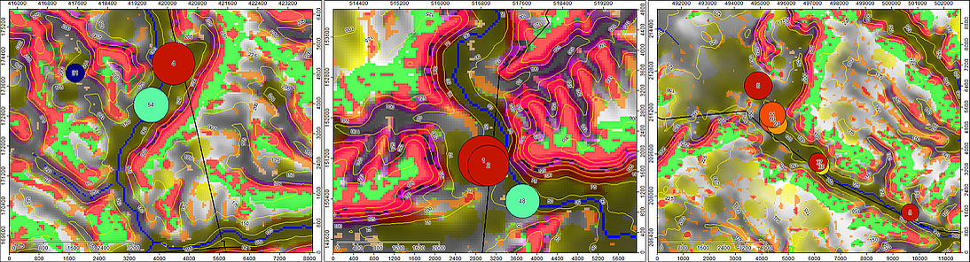
The most likely locations for Boudica's last battle. Left to right: Ogbourne St. George in the Og river valley, Wiltshire (site rank number 4); Dorking in the Mole river valley, Surrey (sites 1 and 2); the Bulbourne river valley in the Chilterns, Hertfordshire (sites 3,5,7,8,10 and 11x2).
Images taken from
Finding the site of Boudica's last battle: multi-attribute analysis of sites identified by template matching, the latest essay on the examination of the possible sites for Boudica's last battle.
The essays and work displayed here started a few years ago as a simple examination of the story of Boudica's uprising against the Roman Empire in 60 or 61 AD, specifically how modern terrain analysis might help find the location of Boudica's last battle.
Since then other techniques have been employed to study Roman army marching camps, the legionary rate of march and energy expenditure, and how dependent the Roman army was on an adequate water supply.
The core approach has been to employ modern techniques and empirical data to shed light on the capacity of the marching, camping, battling and conquering Roman army; for example in the case of Boudica's last battle, the examinations point to where the battle could be sited. In 2014-15 this methodology was applied to the Roman Empire's invasion of Britain in 43 AD, but crucially included reconstructed data on river flow rates, where legionaries could wade rivers and a host of other parameters, all of which pointed to the invasion probably occuring in Kent and the crucial battle at the Medway.
Since 2015 the work has expanded beyond just the Boudica story to include other aspects of Roman Britain, the Roman army and how modern investigative techniques, e.g. LiDAR, can assist in the study of archeaology.
In the 'Papers, essays and Posters' section below will be found all the essays and spreadsheets that have resulted from the method outlined above. The essays are in chronological order - latest at the top. Most are long reads with moderately complex descriptions of methods and outcomes. I hope you enjoy them.
2025 Roman Army Campaigning - (in LibreOffice .ods format). UPDATED Aug 2025.
Improvements and bug fixes. See the 2017 essay below for a description of the spreadsheet and some observations.
2024 Research on the effects of relative sea-level change on the river Exe estuary in the mid-1st century AD (South-West Britain).
Kaye, S., & Pamment Salvatore, J. (2024). Research on the effects of relative sea-level change on the river Exe estuary in the mid-1st century AD (South-West Britain). Limes XXV, Volume 1: CURRENT APPROACHES TO ROMAN FRONTIERS. https://doi.org/10.59641/3d278gp
2023 Roman Army Campaigning - spreadsheet (xlsx).
UPDATED May 2023 with dynamic charts of marching camp defence profiles and camp plans. These simple 2D representations are updated as the user changes values in the spreadsheet giving a visual confirmation of appropriateness.
Spreadsheet calculations for campaigning Roman armies of the early Imperial period. It allows the definition of army sizes, march rates and distances, and the building of camp defences (ditch, rampart and palisade) before calculating over 70 parameters and metrics associated with, for example, marching rates, energy expenditure and Roman marching camps, e.g. outer defences and internal roads. Calculated camps sizes are cross-matched to extant camps allowing comparisons.
Observations from the use of the spreadsheet, together with instructions on how to use, are available in an accompanying essay, "Early Imperial Roman army campaigning: observations on marching metrics, energy expenditure and the building of marching camps", available lower in this list or from Zenodo.org ( https://zenodo.org/record/838275#.ZGSOIHbMIuU ) or Academia.edu
2022 Research on the effects of relative sea-level change on the River Exe estuary in the mid-1st century: implications for the location of Roman sea-port and barge-quay facilities serving the Neronian fortress of Legio II Augusta at Exeter. Steve Kaye and John Pamment Salvatore.
A paper in the book/festschrift 'Roman Frontier Archaeology � in Britain and beyond' in honour of Paul Bidwell presented on the occasion of the 30th annual conference of the Arbeia Society, Archaeopress Roman Archaeology 92. Edited by Nick Hodgson and Bill Griffiths. DOI 10.32028/9781803273440. Open Access https://www.archaeopress.com/Archaeopress/Products/9781803273440
Abstract: see the description below for the corresponding poster.
2022 Research on the effects of Relative Sea-Level change on the River Exe estuary in the mid-1st century AD (South-West Britain). Steve Kaye and John Salvatore. Poster for Limes Congress XXV, Nijmegen, 2022
Relative Sea-Level (RSL) change since the mid-1st century AD places limits on the locations of Roman ports on the River Exe. Supplies from Northern Gaul, destined for the Neronian legionary fortress at Exeter and its dependent civilian sites, may be demonstrated to have been unloaded downriver from the fortress at Exeter.
Utilising a combination of available historical and archaeological data, glacial isostatic adjustment and estimated RSL over the past 2000 years, confirms that Roman sea-transports or river barges could not have reached the Exeter fortress on the tide. Furthermore, on the basis of the estimated tidal reach and depth of the River Exe in the mid-1st century AD, limitations may be placed on the location of both sea-port and barge-quay facilities, thus allowing the areas of search for these installations to be narrowed.
2019 Observations on the Roman road between Exeter, North Tawton and Okehampton. Salvatore, J.P., Kaye, S.J., Stocker, S., Toller, H. Proc. Devon Archaeol. Soc. 77 (2019), 297�319.
A combination of LiDAR satellite imagery, aerial photography, ground observations and excavation has provided evidence for the course of a Roman road both east (where a stretch of the road has been known since the 1950s) and south-west of the Roman fort at North Tawton. An approximate 5.9km length of previously unseen road alignment, where it runs from Hilldown in the parish of Bow eastwards towards the Crediton area has been located, whilst the evidence is also presented for a further unrecorded south-western stretch of approximately 3.4km from the west bank of the Taw across Rowden Moor towards Okehampton.
2017 Early Imperial Roman army campaigning: observations on marching metrics, energy expenditure and the building of marching camps.
This is an essay that accompanies and explains the use of a spreadsheet on Roman army marching and camp building. It allows the definition of army sizes, march rates and distances, and the building of camp defences (ditch, rampart and palisade) before calculating over 70 parameters and metrics associated with a Roman marching camp, e.g internal roads. Calculated camps sizes are cross-matched to extant camps allowing comparisons.
This essay contains a description of the spreadsheet, some observations arising and a description of all input and output variables.
The spreadsheet (updated August 2025 - see above) can be download here - Roman_Army_campaigning.ods
2015 Finding the site of Boudica's last battle: multi-attribute analysis of sites identified by template matching. (Internet Explorer users click here)
This is the latest essay in the series 'Finding the site of Boudica's last battle'. The listing of ranked battle-sites supercedes those in earlier essays (2010 and 2013).
The top 100 candidate battle-sites from this essay can be viewed in Google Earth by downloading this KMZ file.
2015 Kaye, S.J. 2015. The Roman invasion of Britain, 43 AD: riverine, wading and tidal studies place limits on the possible locations of the two-day river battle and beachhead. Archaeologia Cantiana, Vol. 136, 227-240.
2014 The Roman invasion of Britain, 43 AD: riverine, wading and tidal studies as a means of limiting the possible locations of the invasion-ground and the two-day river battle
2013 Observations on marching Roman legionaries: velocities, energy expenditure, column formations and distances
2013 Conference Poster: Searching for Boudica's last battle: an approach via terrain analysis, hydrology and marching camps. Conference 'On Boudica's Trail', Atherstone Civic Soc. at Warwick Uni. (PDF)
2013 Roman marching camps
in Britain: GIS, statistical analysis and hydrological examination of known
camp sites, resulting in the prediction of possible camp sites
2013 Finding the site of Boudica's last battle: Roman logistics
empowered the sword (this is an update of the original essay published in
2012 and contains the author's latest observations on the possible Boudican
battle sites)
2010 Finding the site of Boudica's last battle: an approach via
terrain analysis. A short version of this essay was published in British
Archaeology, Sept/Oct 2010 - Can
Computerised Terrain Analysis Find Boudica's Last Battlefield? (Unfortunately this archived article has not retained its images; a photocopied version, plus images, can be downloaded here)